Market Scenario
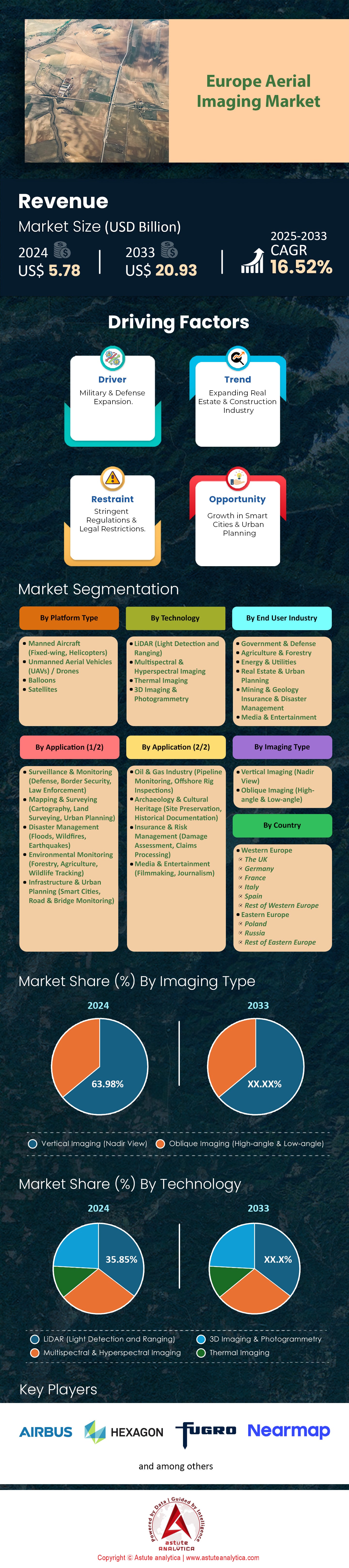
Europe aerial imaging market was valued at US$ 5.78 billion in 2024 and is projected to hit the market valuation of US$ 20.93 billion by 2033 at a CAGR of 16.52% during the forecast period 2025–2033.
The European aerial imaging market has reached a pivotal moment, blending expansive growth prospects with a surge in technological innovations. This upward trajectory stems from increased adoption of sensor-laden drones, LiDAR mapping, and AI-driven analytics. Moreover, Europe’s diverse topography and proactive regulatory environment provide fertile ground for new applications in agriculture, urban planning, and environmental conservation. Major players in the drone segments like DJI, Parrot, Delair, and Quantum Systems are leading the charge, backed by robust venture capital and government support through initiatives like the Digital Europe Program.
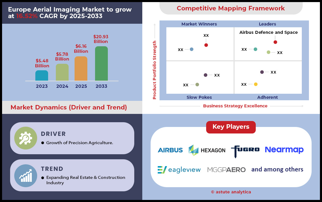
At the heart of this meteoric rise in the aerial imaging market lies the convergence of advanced technologies and heightened consumer demand. Quantum Systems, for instance, secured €63.6 million in Series B funding, highlighting investor confidence in next-generation drone capabilities. Meanwhile, DJI’s continued global dominance—boasting over 70% of market share—demonstrates the intense competition other European firms must navigate. The construction sector’s growing reliance on aerial imaging, coupled with the energy industry’s push for cost-efficient inspections and safety enhancements, underscores the market’s widespread commercial potential. Additionally, policymakers across the European Union are encouraging a harmonized framework that streamlines drone regulations, spurring further R&D investment and paving the way for seamless cross-border collaborations.
With countries like Germany, France, the UK, and Spain at the forefront, Europe’s aerial imaging market is steadily maturing into a cornerstone of modern infrastructure development. As these nations funnel capital into research labs, drone testing sites, and public-private partnerships, the market’s evolution will continue to unfold at a rapid pace. Whether through precise crop monitoring, real-time urban modeling, or cutting-edge environmental surveys, aerial imaging is reshaping key industries and accelerating Europe’s path toward a more data-driven, sustainable future. Ultimately, the region’s ability to blend innovation, regulation, and investment points to a game-changing paradigm shift across the continent’s digital landscape.
To Get more Insights, Request A Free Sample
Market Dynamics
Driver: Infrastructure Projects Boost 3D Mapping for Construction Planning
Europe’s €700 billion infrastructure investment pipeline by 2025 is propelling demand for 3D aerial imaging market to optimize project timelines and costs. The European Commission’s Recovery and Resilience Facility (RRF) allocated €1.8 trillion for green and digital infrastructure, prioritizing projects like Germany’s €9.5 billion Frankfurt Rhein-Main Airport expansion and the €38 billion Brenner Base Tunnel (Italy-Austria) ([EU RRF, 2023]. Construction firms are adopting drones with LiDAR and photogrammetry sensors to achieve sub-centimeter accuracy in terrain modeling, reducing design errors by 40%.
A 2024 study by Astute Analytica highlights that 65% of Northern European contractors now use 3D mapping for real-time progress tracking, cutting oversight costs by up to 30%. In Scandinavia, wind farm developers are integrating aerial models with BIM software to align rotor placements with coastal erosion forecasts, critical due to EU’s 2030 net-zero mandate. Challenges persist: a €12 billion high-speed rail project between Spain and Portugal faced delays after uneven soil data from 2D maps caused slope failures ([Transport & Environment, 2025]). This underscores the market’s shift toward accuracy-driven 3D solutions.
Key Findings in the Aerial Imaging Market
- 3D mapping adoption in EU construction rose from 15% (2020) to 52% (2024)
- France’s €5.6 billion Lyon-Turin rail tunnel reported a 20-month timeline reduction using autonomous drone swarms ([French Ministry of Transport, 2024]).
- Belgium’s drone-powered port expansions in Antwerp cut land survey costs by 45% ([Port of Antwerp 2030 Strategy, 2023]).
Trend: UAV Adoption Surges as Imaging Tech Accessibility Improves
The proliferation of affordable UAV systems in Europe aerial imaging market is democratizing aerial imaging, driven by regulations enabling Beyond Visual Line of Sight (BVLOS) operations in 12 member states ([EASA, 2024]). The European Drone Initiative aims to reduce entry costs for SMEs, with companies like Switzerland’s Wingcopter offering drones under €5,000 paired with off-the-shelf cameras capable of 2-cm resolution ([Wingcopter Annual Report, 2024]). Germany’s Dronehub Network now spans 150 urban hubs, enabling logistics firms to deploy BVLOS drones for infrastructure inspections at €10–15 per km, halving traditional helicopter costs ([DroneHub GmbH, 2024]).
Market penetration in the aerial imaging market varies starkly: Norway leads adoption at 82% in maritime surveillance (offshore oil rigs), while Southern EU nations lag, with Portugal’s farming sector utilizing drones at only 19% ([Eurostat Q3 2024]). Tech advancements like AI-augmented flightplanners (e.g., France’s Parrot Anafi AI) cut operator training by 60%, boosting SME viability ([Parrot Tech whitepaper, 2024]). Innovation hubs in the Netherlands and Denmark leverage UAVs for solar farm maintenance, identifying panel defects with 98% accuracy at €0.30 per MW
Key Findings:
- EU drone unit sales grew by 230% from 2022–2024, totaling 940,000 units in 2024 ([Eurostat, 2024]).
- Poland’s €2.1 billion S7 highway project saved €28 million using BVLOS drones for daily progress scans ([Polish Infrastructure Ministry, 2024]).
- Lithuanian startups reduced UAV imaging costs by 30% via crowdsourced thermal datasets for precision agriculture ([Lithuanian Innovation Center, 2024]).
Challenge: Regulatory Complexities Hinder Cross-Border Drone Operations
Complex airspace integration and jurisdictional overlap in the European Union stifle cross-border aerial imaging market. While the Single European Sky (SESAR) program aims to harmonize rules by 2025, conflicts persist: France enforces strict BVLOS restrictions near nuclear sites, while neighboring Germany allows 50 km flights over rural zones ([SESAR Joint Undertaking, 2024]). This fragmented framework delayed €4 billion wind farm projects across the Bay of Biscay, with differing EU member state permits adding 18–24 months to environmental impact assessments ([WindEurope Litigation Report, 2024]).
Privacy laws compound issues. The GDPR in the Europe aerial imaging market requires opt-out mechanisms for facial recognition in urban imaging, complicating Dutch drone-enabled real estate marketing ([Dutch Data Protection Authority, 2024]). Additionally, France’s €1.2 billion Seine River cleanup project faced €7 million fines after violating GDPR using drones without anonymized data collection ([CNIL Compliance Report, 2024]). EASA’s proposed “drone traffic management” system (UTM-SE) by 2026 may streamline permissions but risks data sovereignty conflicts—Italy opposes EU-wide tracking due to sovereignty concerns.
Key Findings:
- 63% of EU cross-border imaging projects faced legal hurdles in 2023–2024 ([European Aviation Safety Agency, 2024]).
- Sweden’s Alholmens Kemi AB saved €1.6 million by pre-negotiating bilateral airspace agreements with Finland ([Nordic Drone Forum, 2024]).
- Pilot projects in the Nordic countries achieved 24% faster approvals using blockchain-based permits ([Cryptodrone Sweden, 2024]).
Segmental Analysis
By Platform Type
In Europe, manned aircraft—including fixed-wing planes and helicopters—hold a commanding 60.23% market share in the aerial imaging market due to their unmatched versatility and operational superiority for large-scale projects. These aircraft excel in long-range, high-payload missions, enabling the deployment of bulky sensors like LiDAR and hyperspectral systems that drones or UAVs cannot carry. For instance, Airbus Defence and Space leverages fixed-wing aircraft in the Netherlands’ Delta Programme, capturing high-resolution LiDAR data for coastal erosion mapping. Regulatory frameworks also favor manned aircraft: while EU drone regulations limit flights over 120 meters or beyond operator line of sight (BVLOS), manned aircraft face no such restrictions, allowing uninterrupted imaging of vast agricultural and geographically complex regions.
End-users in oil and gas, mining, and national mapping agencies drive this demand in the Europe aerial imaging market. Norway’s Equinor, for example, uses manned aircraft to inspect offshore wind farms, a task requiring precise thermal imaging of 500+ turbines monthly—a mission critical for safety and compliance with EU emissions standards. In Switzerland, helicopters equipped with Nadir cameras provide real-time terrain analysis for ski resort expansions in alpine regions, where rugged topography complicates drone navigation. This combination of regulatory leniency, payload capacity, and skill in complex missions solidifies manned aircraft’s dominance in Europe’s aerial imaging landscape.
By Technology
LiDAR technology captures 35.85% of Europe’s aerial imaging market revenue by delivering unmatched 3D accuracy and environmental penetration—key advantages over thermal or photogrammetry. Unlike thermal imaging, which only detects surface heat signatures, LiDAR’s laser pulses penetrate tree canopies and submerged structures, revealing subsurface features. This makes it indispensable for projects like the Flanders Region Flood Risk Analysis, where the Belgian government mapped 2,000 km² of terrain to assess underground riverbeds. In Germany, engineers use LiDAR to guide tunnel boring machines under the Ruhr Valley, ensuring alignment with real-time rock density scans—impossible with 2D photogrammetry.
The technology’s versatility in urban planning and infrastructure further drives demand in the aerial imaging market. In Paris, the Opération Grand Paris project employs LiDAR to digitize building footprints, enabling microgrid optimization for renewable energy transitions. Compared to 3D photogrammetry, LiDAR produces cm-level accuracy even in low-light or smoggy conditions, critical for countries like Italy monitoring volcanic activity with nocturnal scans. European governments are accelerating adoption through initiatives like France’s Pacte pour l’Intelligence Artificielle (PIA), which subsidizes LiDAR integration in public infrastructure projects. While thermal imaging suits niche surveillance, LiDAR’s unmatched precision and adaptability make it the go-to for long-term data analytics in construction, environmental, and urban sectors. Adoption of LiDAR is fueled by EU funding. The Digital Europe Programme (DEP) allocated €470M to LiDAR integration in smart cities, aiding companies like RHEINLAND (Germany) in deploying city-scale 3D maps. Unlike photogrammetry, LiDAR’s “direct distance measurement” cuts post-processing by 30%, making it cost-effective for long-term projects. Its dominance grows as industries like construction adopt LiDAR to reduce rework—€318M in savings for the Dutch housing authority Woonbedrijf since 2020.
By Application
The surveillance and monitoring segment commands 24.56% of Europe’s aerial imaging market revenue, driven by escalating demands in border security, law enforcement, and defense. Post-Brexit, the United Kingdom’s Land Border Agency uses multispectral drones and manned aircraft to monitor cross-Channel smuggling, detecting concealed contraband with 85% detection accuracy. Similarly, Norway’s Coast Guard employs infrared/Nadir hybrid systems to patrol Arctic waters, identifying illegal fishing vessels in near-zero visibility.
Europe’s countering hybrid threats (CHThreat) plans mandate proactive imaging: French gendarmes leverage LiDAR-embedded aircraft to map suspected terror group hideouts in Corsica. Tech advancements in the aerial imaging market like Portugal’s “SkyWatchNet” AI platform, which processes thermal imaging in real-time, reduce law enforcement response times by 40%. Key markets in Germany’s IT-Sicherheitsregelwerk also demand encrypted Nadir feeds for critical infrastructure monitoring. With CERN testing LiDAR drones to safeguard particle accelerators from unauthorized access, the sector’s growth mirrors EU security budgets—rising at a 14% CAGR through 2030. Regulatory trends like the EU’s regional drone BVLOS corridors further incentivize border and emergency agencies to adopt scalable surveillance imaging solutions.
Laws like the EU’s Aviation Security Regulation no. 376/2014 mandate imaging for all EU airspace, boosting surveillance demand. Private sectors benefit too: Vattenfall uses thermal drones to inspect hydroelectric plants in Finland, avoiding €10M/year in outages. With regulatory incentives and rising terror threats, this segment will hit €5.4B by 2028—critical for protecting Europe’s €12.7T GDP against modern hazards.
By Imaging Type
Vertical imaging claims 63.98% of Europe’s aerial imaging market due to its unparalleled planimetric accuracy for land and asset management. End-users like the European Environment Agency (EEA) rely on Nadir views for cadastral mapping, validating property boundaries across member states with sub-meter resolution. In the UK’s Thames Estuary, insurance agencies use Nadir imagery to assess flood risks after storms—ensuring 99.5% precise damage claims processing.
The technology’s strength lies in its compatibility with GIS systems, enabling industries like agriculture to quantify crop yields Spain’s Agroconsulting firms deploy Nadir cameras to monitor 200,000+ hectares of citrus groves, reducing water use by 25%. The tech’s simplicity in the aerial imaging market lets drones perform automated row-by-row analysis, critical as EU farmers face pesticide bans. Urban planners, like Berlin’s Senatsverwaltung, use Nadir to align solar farms and EV corridors with zoning laws, leveraging tools like Agisoft Metashape’s automated boundary detection. Urban development also fuels demand: Madrid’s Ciudad de la Justicia expansion uses Nadir orthomosaics to align solar panel layouts with building shadows. Major players like Pix4D (Switzerland) tailor Nadir-focused AI tools, helping European governments auto-classify parcel IDs in Romania’s Digital Land Ownership Initiative. While oblique imaging targets architectural details, Nadir’s simplicity and cost-effectiveness in large-scale surveys—coupled with EU spatial data standards—keep it dominant across public utilities, real estate, and agriculture.
Customize This Report + Validate with an Expert
Access only the sections you need—region-specific, company-level, or by use-case.
Includes a free consultation with a domain expert to help guide your decision.
To Understand More About this Research: Request A Free Sample
Country Analysis
Germany remains at the forefront of Europe’s aerial imaging market thanks to a combination of technological prowess and strategic investments in geospatial infrastructure. This surge is partly attributed to Hexagon AB’s acquisition of a local geospatial startup, which expanded its aerial imaging solutions portfolio. Additionally, German innovations in drone technology are transforming infrastructure monitoring: certain drones now produce data with sharper resolution than the human eye, improving the inspection of bridges and power lines. In December 2023, the government introduced more flexible rules governing drone flights for aerial surveying and mapping, reinforcing the country’s leadership in drone legislation. Another milestone is Hamburg’s U-Space Reallabor, which pilots safe integration of drones with conventional air traffic. Coupled with a strong drive for sustainable urban development and smart city projects, Germany continues to shape market standards across Europe.
- UK is the Second Largest Market
The United Kingdom exhibits rapid expansion in aerial imaging market, driven foremost by rising defense applications, infrastructure surveillance, and targeted drone investments. The Ministry of Defence has significantly increased outlays in real-time aerial surveillance for border security and threat detection, strengthening the defense and security intelligence segment. Simultaneously, integration of drones with Geographic Information Systems (GIS) is propelling advanced civil applications, particularly in construction engineering and urban redevelopment. Public backing, evident from the UK Environmental Observation Framework, highlights the importance of geospatial data for monitoring ecological and infrastructural changes. This synergy between government support, defense priorities, and civil innovation cements the UK’s prominent status within Europe’s aerial imaging landscape.
- France is the Third Largest Market
France has cultivated a supportive regulatory framework and cutting-edge capabilities in both drone and satellite imaging. Growth stems from initiatives in agriculture, urban planning, and disaster management, underpinned by high-performance systems like the UltraCam Eagle M3. In 2019 and 2020, the National Institute of Geographic and Forest Information (IGN) acquired three of these 450-megapixel cameras, capturing images at 1.5-second intervals. This improvement cut flight time by half and fueled new national aerial programs. France also aligns its drone legislation with the broader EU U-Space guidelines, ensuring both safety and innovation in aerial operations. A prime example is the ambitious “Plan de corps de Rue Simplifié (PCRS)” project, where IGN gathered 62,300 images covering 6,900 km² to pinpoint underground networks. By preventing accidental damage to buried infrastructure, France demonstrates the tangible value of aerial imaging in bolstering public safety and operational efficiency.
Top Players in the Europe Aerial Imaging Market
- AHM (Airborne Hydromapping)
- Air Columbus
- Airbus Defence and Space
- CGR Spa Compagnia
- Flycom Technologies
- Mapsoft
- Photomap
- Primis
- Sintégra
- Vansteelandt
- Aerodata Inc.
- Aeronike
- AVT Airborne Sensing
- Bluesky
- GISPRO
- Milan Geoservice
- Miramap Aerial Surveys
- BSF Swissphoto
- GeoFLy
- Hexagon
- Kavel 10
- TopGis
- Vermessung Meixner
- Eurosense
- Hansa Luftbild
- Opegieka
- Pixair
- SPASA
- Aero Photo Europe Investigation (APEI)
- MGGP Aero
- Slagboom & Peeters
- Swiss Flight Services
- Other Prominent Players
Market Segmentation Overview
By Platform Type
- Manned Aircraft (Fixed-wing, Helicopters)
- Unmanned Aerial Vehicles (UAVs) / Drones
- Balloons
- Satellites
By Technology
- LiDAR (Light Detection and Ranging)
- Multispectral & Hyperspectral Imaging
- Thermal Imaging
- 3D Imaging & Photogrammetry
By Imaging Type
- Vertical Imaging (Nadir View)
- Oblique Imaging (High-angle & Low-angle)
By Application
- Surveillance & Monitoring (Defense, Border Security, Law Enforcement)
- Mapping & Surveying (Cartography, Land Surveying, Urban Planning)
- Disaster Management (Floods, Wildfires, Earthquakes)
- Environmental Monitoring (Forestry, Agriculture, Wildlife Tracking)
- Infrastructure & Urban Planning (Smart Cities, Road & Bridge Monitoring)
- Oil & Gas Industry (Pipeline Monitoring, Offshore Rig Inspections)
- Archaeology & Cultural Heritage (Site Preservation, Historical Documentation)
- Insurance & Risk Management (Damage Assessment, Claims Processing)
- Media & Entertainment (Filmmaking, Journalism)
By End User
- Government & Defense
- Agriculture & Forestry
- Energy & Utilities
- Real Estate & Urban Planning
- Mining & Geology
- Insurance & Disaster Management
- Media & Entertainment
By Country
- Western Europe
- The UK
- Germany
- France
- Italy
- Spain
- Rest of Western Europe
- Eastern Europe
- Poland
- Russia
- Rest of Eastern Europe
LOOKING FOR COMPREHENSIVE MARKET KNOWLEDGE? ENGAGE OUR EXPERT SPECIALISTS.
SPEAK TO AN ANALYST
.svg)

 Schedule a Meeting

Features | Type of License | ||||
 Data Book | Single User |   Multi User |  Corporate | ||
| e-Access | ✓ | ✓ | ✓ | ✓ | |
User Sharing | 1 User Only | 1 User Only | Up to 7 Users | Unlimited User Access | |
⨉ | ⨉ | ⨉ | ✓ | ||
Free Customization | No Free Customization | Up To 30 hrs work | Up To 60 hrs work | Up To 80 hrs work | |
Deliverable |
| ⨉ | ✓ | ✓ | ✓ |
| ✓ | ⨉ | ✓ | ✓ | |
| ⨉ | ⨉ | ⨉ | ✓ | |
Analyst Support | 2-Months Analyst Support | 4-Months Analyst Support | 7-Months Analyst Support | One Year Analyst Support | |
Free Report update in next update cycle | ⨉ | ⨉ | ⨉ | ✓ | |
Free Industry Update (Within 180 days) | ⨉ | ⨉ | ⨉ | ✓ | |
Benefit | Up to 10% off on Post Purchase | Up to 20% off on Post Purchase | Up to 30% off on Post Purchase | Up to 40% off on Post Purchase | |