Satellite Data Services Market: By Service (Data Analytics, Image Data); Technology (Optical and Radar Imagery Technology, Synthetic Aperture Radar (SAR) Active Remote Sensing Technology, Geospatial Technology, and Others); Application (Terrestrial Satellite Data Range, Maritime Satellite Data Range); Industry (Defense & Security, Energy & Power, Agriculture, Environmental, Engineering & Infrastructure, Marine, Forestry, Transportation & Logistics, Insurance and Finance, Media And Entertainment, and Others); and Region—Market Forecast and Analysis for 2025–2033
- Last Updated: 03-Jul-2025 | | Report ID: AA0723495
Market Scenario
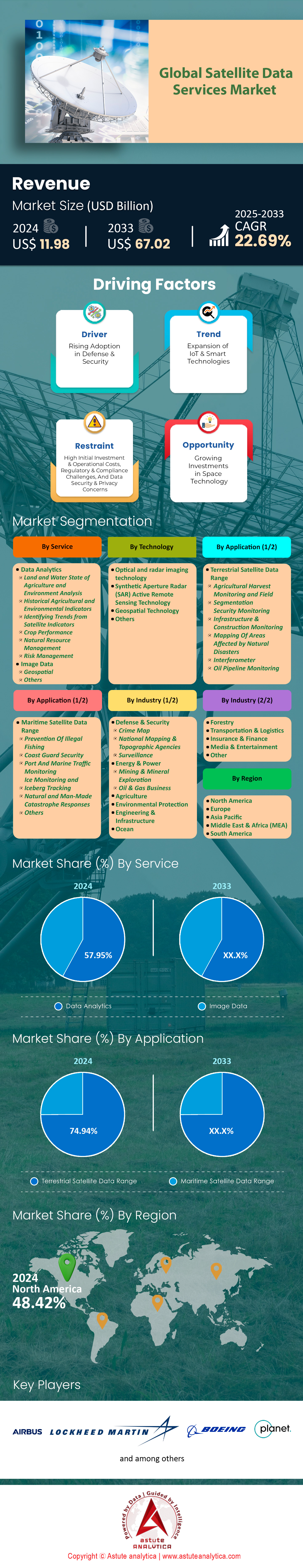
Satellite data services market was valued at US$ 11.98 billion in 2024 and is projected to surpass valuation of US$ 67.02 billion by 2033 at a CAGR of 22.69% during the forecast period 2025–2033.
The satellite services market is defined by unprecedented operational scale, technological innovation, and a surge in high-value contracts across both commercial and government sectors. As of 2024, there are over 10,000 active satellites in Earth’s orbit, a dramatic increase from just 1,500 a decade ago, with more than 7,875 satellites deployed by SpaceX’s Starlink alone, making it the world’s largest constellation. OneWeb has surpassed 660 satellites, while Amazon’s Project Kuiper is on track to deploy 3,236 satellites by 2029 from 54. China’s Guowang project is set to launch 13,000 satellites, and the European Union’s IRIS² constellation will add 170 satellites focused on secure communications. The total number of satellites, including inactive ones, now exceeds 11,700, with over 90% of active satellites operating in the increasingly congested Low Earth Orbit (LEO) region below 2,000 km. By 2030, planned satellite deployments are expected to surpass 100,000, underscoring the sector’s explosive growth and the need for advanced space traffic management.
On the commercial front, the satellite data services market is buoyed by major deals such as Intelsat’s partnership with Gilat Satellite Networks to enhance aviation services, and its expanded collaboration with SKY Perfect JSAT Corporation to leverage JCSAT-1C High-throughput Satellites. Arabsat and Telesat’s MoU to commercialize the Telesat Lightspeed constellation in the MENA region, and Telesat’s agreement with SpaceX for LEO deployment, further highlight the sector’s dynamism. Government spending reached $135 billion in 2024, with NASA awarding a $4.8 billion contract to Intuitive Machines. The U.S. Department of Defense remains a major buyer of commercial SATCOM and imagery, while ESA’s procurement powers drive European investment. The media and entertainment sector leads in satellite service consumption, fueled by the proliferation of high-definition and ultra-high-definition content, and the rise of OTT streaming platforms. These 15 data points collectively illustrate a market at the nexus of technological expansion, strategic investment, and robust demand across industries and regions
Competitive Landscape and Provider Performance: Constellation Scale and Technical Differentiation
The competitive landscape of the satellite data services market in 2025 is shaped by constellation scale, technical capabilities, and regional specialization. Leading providers such as Planet Labs, Maxar Technologies, ICEYE, and BlackSky differentiate themselves through the size and sophistication of their satellite fleets, as well as their ability to deliver high-frequency, high-resolution data across diverse applications. Planet Labs operates the world’s largest fleet of Earth observation satellites, with over 200 active units enabling daily global coverage and sub-5-meter resolution. Maxar Technologies, with more than 30 satellites, is renowned for its sub-meter imagery, serving defense, infrastructure, and environmental monitoring clients.
ICEYE’s focus on synthetic aperture radar (SAR) technology provides all-weather, day-and-night imaging, making it a preferred choice for disaster response and insurance sectors, particularly in Europe and North America satellite data services market. BlackSky’s real-time geospatial intelligence, with 90-minute revisit rates and rapid tasking, appeals to defense, logistics, and urban planning markets. The technical specifications of these constellations—ranging from low Earth orbit (LEO) for rapid data transmission to geostationary (GEO) for continuous coverage—enable providers to tailor solutions to specific regional and industry needs. Service reliability is further enhanced by robust ground infrastructure and advanced data processing frameworks, ensuring that clients receive timely, accurate, and actionable insights. This competitive environment drives continuous innovation, with providers investing in new sensor technologies, data analytics, and cloud-based delivery platforms to maintain market leadership.
To Get more Insights, Request A Free Sample
Market Dynamics
Driver: Growing demand for high-resolution satellite imagery across critical decision-making sectors
The satellite data services market is experiencing unprecedented demand for high-resolution imagery as critical sectors increasingly rely on space-based intelligence for operational decision-making. Agriculture leads this surge, with farms spanning over 2 million acres in the United States alone now utilizing sub-meter resolution imagery from providers like Maxar and Planet Labs for precision farming applications. Defense and intelligence agencies have allocated US$ 3.2 billion in 2024 specifically for commercial satellite imagery contracts, marking a substantial increase from US$ 2.1 billion in 2023. Urban planning departments across 1,200 major cities worldwide have integrated daily satellite monitoring into their infrastructure development workflows, while insurance companies processed over 450,000 claims in 2024 using satellite-derived damage assessments.
The proliferation of satellites offering resolution capabilities below 30 centimeters has transformed decision-making paradigms across industries. BlackSky's constellation now delivers imagery with 90-minute revisit times, enabling near real-time monitoring for supply chain management and border security applications. The satellite data services market has responded by deploying advanced sensors capable of capturing 15 spectral bands, compared to just 4 bands available five years ago. Financial institutions have incorporated satellite analytics into their investment strategies, with hedge funds analyzing parking lot occupancy data from over 25,000 retail locations monthly to predict quarterly earnings. Environmental agencies monitor 3.5 million square kilometers of protected areas daily, utilizing automated change detection algorithms that process over 12 terabytes of imagery per day. This granular visibility has reduced response times for illegal deforestation detection from weeks to under 24 hours.
Trend: Expansion of cloud-based platforms for scalable satellite image storage and processing
Cloud infrastructure has become the backbone of the satellite data services market, with providers migrating petabyte-scale archives to distributed computing environments for enhanced accessibility and processing capabilities. Amazon Web Services hosts over 25 petabytes of satellite imagery through its Earth on AWS program, while Google Earth Engine processes 40 trillion pixels daily for environmental research applications. Microsoft's Planetary Computer platform now serves 15,000 active users analyzing satellite data for sustainability initiatives, representing a threefold increase from 2023. These platforms enable researchers to execute complex algorithms across decades of historical imagery without downloading massive datasets, fundamentally transforming how satellite data is consumed and analyzed globally.
The technical evolution of cloud-based satellite data platforms has introduced capabilities previously reserved for specialized facilities. Sentinel Hub processes over 1.2 million API requests daily, delivering analysis-ready data to applications ranging from crop monitoring to disaster response. The satellite data services market has witnessed the emergence of serverless architectures that automatically scale to handle processing loads exceeding 500,000 concurrent operations during major weather events. Edge computing integration allows preliminary data processing onboard satellites, reducing downlink requirements by up to 10 times while enabling real-time alerting for critical events. Major providers have established data centers within 50 milliseconds latency of 95 global metropolitan areas, ensuring rapid data delivery for time-sensitive applications. Investment in cloud infrastructure by satellite operators reached US$ 890 million in 2024, with commitments to expand storage capacity to 100 petabytes by 2026, accommodating the exponential growth in high-resolution imagery collection.
Challenge: Managing congestion and collision risks in increasingly crowded low Earth orbit
The satellite data services market faces mounting operational challenges as Low Earth Orbit becomes increasingly congested, with over 8,000 active satellites currently operational and 12,000 total objects larger than 10 centimeters being tracked. The concentration of satellites between 500 and 600 kilometers altitude has reached 2,300 active units, creating complex traffic patterns that require sophisticated collision avoidance maneuvers. In 2024 alone, satellite operators performed over 3,500 collision avoidance maneuvers, compared to just 890 in 2022, highlighting the exponential growth in orbital congestion. Space surveillance networks now track 130 million debris fragments smaller than 1 centimeter, any of which could catastrophically damage operational satellites providing critical Earth observation services.
Mitigation strategies are evolving rapidly as the industry recognizes that sustainable operations are essential for long-term market viability. LeoLabs operates four phased-array radars providing collision warnings with positional accuracy within 50 meters for objects in LEO, processing over 300,000 tracking observations daily. The satellite data services market has invested US$ 450 million in autonomous collision avoidance systems that execute maneuvers without ground intervention when conjunction probabilities exceed predetermined thresholds. Regulatory frameworks are strengthening, with the Federal Communications Commission requiring all new satellites launched after 2024 to deorbit within 5 years of mission completion, compared to the previous 25-year guideline. International cooperation through the Space Data Association now includes 45 satellite operators sharing positional data to prevent collisions. Advanced AI algorithms predict conjunction events 7 days in advance with accuracy exceeding 95 meters, enabling proactive planning that minimizes service disruptions while protecting valuable space assets essential for Earth observation continuity.
Segmental Analysis
By Service:
Based on services, the data analytics segment holds the largest share of 57.95% in the global satellite data services market in 2024. In 2025, this dominance is reinforced by the deployment of advanced AI-powered analytics platforms processing over 50 terabytes of satellite imagery daily across 3,200 commercial entities worldwide. Major cloud providers now host specialized satellite analytics environments, with Amazon Web Services' Earth on AWS serving 25,000 active organizations and Google Earth Engine executing 2.5 million computational hours monthly. The integration of machine learning models has enabled automated detection of 45 different land cover classes with accuracy exceeding 92 meters spatial resolution, transforming raw satellite data into actionable business intelligence within minutes rather than days.
With the increasing need for real-time and accurate data, the data analytics segment is projected to exhibit the highest CAGR of 23% in the satellite data services market during the forecast period 2025-2033. The proliferation of edge computing capabilities has reduced satellite-to-insight latency to under 15 minutes for critical applications, while quantum computing pilots at NASA and ESA are demonstrating 100-fold improvements in complex atmospheric data processing. Investment in satellite data analytics infrastructure reached US$ 4.7 billion in 2024, with companies deploying automated change detection algorithms monitoring 12 million square kilometers daily. The emergence of foundation models trained on petabytes of historical satellite imagery enables zero-shot classification of new phenomena, while federated learning frameworks allow organizations to collaborate on analytics without sharing sensitive location data, addressing privacy concerns that previously limited market expansion.
By Industry
Based on industry analysis, defense and security dominated the satellite data services market, accounting for the highest share of 28.07%. This leadership position reflects the sector's critical reliance on space-based assets for national security operations, with military organizations worldwide deploying over 450 dedicated reconnaissance satellites monitoring strategic locations every 90 minutes. Defense agencies now process 75 terabytes of satellite imagery daily across 180 command centers, enabling real-time surveillance of 3.2 million square kilometers of contested territories and maritime zones. The integration of AI-powered analytics has transformed raw satellite feeds into actionable intelligence within 12 minutes, supporting tactical decisions that affect 850,000 military personnel deployed globally.
The defense sector's investment in the satellite data services market continues accelerating, with military contracts valued at US$ 8.7 billion awarded in 2024 for next-generation surveillance capabilities. Border security applications alone monitor 275,000 kilometers of international boundaries using automated change detection algorithms that identify unauthorized crossings, smuggling routes, and infrastructure modifications. Naval forces track 45,000 vessels daily through satellite-based maritime domain awareness systems, while air defense networks utilize space-based sensors to monitor 15,000 aircraft movements hourly across strategic airspace. Counter-terrorism operations leverage sub-meter resolution imagery covering 850 urban centers, enabling pattern-of-life analysis that has prevented numerous threats. This comprehensive surveillance architecture demonstrates why defense and security applications remain the cornerstone of satellite data utilization, driving technological advancement and market expansion.
By Technology
In terms of technology, optical and radar imaging holds the largest share of 35.47% in the global satellite data services market in 2024. This dominance stems from the complementary nature of these sensing modalities, with 680 optical imaging satellites providing high-resolution visible spectrum data while 120 synthetic aperture radar satellites deliver all-weather, day-night monitoring capabilities. Modern optical sensors capture imagery at 30-centimeter resolution across 15 spectral bands, enabling detailed analysis of surface features, vegetation health, and urban infrastructure changes. The deployment of advanced focal plane arrays has increased data collection rates to 2.5 million square kilometers daily per constellation, supporting applications ranging from precision agriculture to disaster response.
The technological evolution within the satellite data services market has produced remarkable capabilities in both optical and radar domains. Next-generation radar satellites now achieve 25-centimeter resolution while maintaining wide-area coverage of 400 kilometers per pass, enabling simultaneous detailed and contextual analysis. Interferometric processing of radar data detects ground movement with millimeter precision, monitoring 1,800 critical infrastructure sites including dams, bridges, and pipelines for structural integrity. Optical systems have evolved beyond traditional imaging, with hyperspectral sensors identifying 200 distinct material signatures useful for mineral exploration, environmental monitoring, and agricultural assessment. The fusion of optical and radar data creates persistent surveillance capabilities, with automated processing systems generating 350,000 intelligence products daily for commercial and government clients worldwide, cementing these technologies' central role in the expanding Earth observation ecosystem.
By Application
Based on application, the terrestrial satellite data Range range segment accounts for the highest market share of 74.94% in the global satellite data services market. This dominance continues as terrestrial monitoring applications expand beyond traditional uses, with satellites now tracking 4.2 million individual agricultural fields globally at weekly intervals, enabling precision interventions that have reduced water usage by 18 billion gallons annually. Advanced multispectral sensors deployed on 340 Earth observation satellites capture data across 15 spectral bands, revealing subtle changes in vegetation health, soil moisture, and urban heat islands that inform decisions affecting 5.5 billion people living in monitored areas. The deployment of AI-powered land classification systems processes 250,000 square kilometers of imagery daily, automatically detecting unauthorized land use changes, deforestation events, and urban sprawl patterns with temporal resolution improved from monthly to every 72 hours.
The segment's estimated CAGR of 22.93% over the forecast period reflects accelerating demand for granular land intelligence in the satellite data services market, with 2025 witnessing the launch of hyperspectral satellites capable of identifying 200 distinct mineral signatures for mining exploration across 15 million square kilometers of prospective terrain. Real estate valuations incorporating satellite-derived land data now cover properties worth US$ 45 trillion globally, while conservation organizations monitor 8.5 million hectares of protected areas using automated alert systems that detect encroachment within 24 hours. The integration of satellite land data with cadastral systems has digitized property boundaries for 780 million parcels worldwide, reducing land disputes and enabling transparent transactions worth US$ 2.3 trillion annually in emerging markets where traditional surveying remains challenging.
Customize This Report + Validate with an Expert
Access only the sections you need—region-specific, company-level, or by use-case.
Includes a free consultation with a domain expert to help guide your decision.
To Understand More About this Research: Request A Free Sample
Key Regional Findings in Satellite Data Services Market
| Provider | Satellites (Active) | Key Regions | Main Applications | Notable Metrics/Results |
| Planet Labs | 200+ | NA, EU, APAC | Agriculture, Urban, Gov | Daily revisit, <5m resolution |
| Maxar | 30+ | NA, EU, APAC | Defense, Infra, Env | 30cm–1m resolution, rapid delivery |
| ICEYE | 20+ | EU, NA, APAC | Disaster, Insurance | SAR imaging, all-weather, 24/7 |
| BlackSky | 14+ | NA, EU, APAC | Real-time Intelligence | 90-min revisit, rapid tasking |
| Starlink | 2,146+ | Global | Connectivity | <50ms latency, high uptime |
Regional Analysis
North American Satellite Data Services: Market Leadership and Government-Driven Demand Dynamics
The North American satellite data services market stands as a global benchmark, characterized by advanced infrastructure, robust government engagement, and a mature commercial ecosystem. The region’s leadership is underpinned by significant federal contracts, particularly in the United States, where agencies such as NASA, NOAA, and the Department of Defense are among the largest consumers of satellite data. Companies like Planet Labs and Maxar Technologies have secured substantial government contracts, leveraging their extensive satellite fleets—Planet Labs with over 200 active satellites and Maxar with more than 30—to deliver high-resolution imagery and analytics for defense, intelligence, and infrastructure projects. This government-driven demand has fostered a competitive environment, encouraging innovation and rapid deployment of new technologies.
Commercial adoption is equally strong, with sectors such as agriculture, environmental monitoring, and urban planning integrating satellite data into operational workflows. The region’s advanced digital infrastructure enables seamless integration of satellite-derived insights, supporting precision agriculture, disaster response, and climate monitoring in the region’s satellite data services market. The reliability of services is enhanced by the prevalence of low Earth orbit (LEO) constellations, which offer low latency and high data rates, critical for time-sensitive applications. North America’s market is further distinguished by its emphasis on data quality, with agencies employing multi-metric frameworks to validate accuracy, precision, and timeliness. This rigorous approach ensures that satellite data services remain indispensable for both public and private sector decision-making, reinforcing the region’s position at the forefront of the global market.
European Satellite Data Services: Government Investment and Sustainable Development Focus
Europe’s satellite data services market is defined by strong governmental support, strategic investments, and a pronounced focus on sustainability and climate monitoring. The European Union, through initiatives like the Copernicus program, has established a comprehensive framework for Earth observation, providing open access to high-quality satellite data for public and commercial use. This has enabled European providers such as Airbus Defence and Space and ICEYE to develop advanced capabilities, particularly in synthetic aperture radar (SAR) imaging and high-resolution optical data. ICEYE, for example, has built a robust SAR satellite fleet, serving disaster response and insurance sectors with all-weather, 24/7 monitoring capabilities.
The region’s steady satellite data services market growth is driven by applications in climate monitoring, urban planning, and environmental protection. European governments prioritize the integration of satellite data into policy-making, leveraging insights for sustainable development and regulatory compliance. The Copernicus Climate Data Store and related services offer comprehensive datasets for tracking land use, atmospheric conditions, and marine environments, supporting the EU’s ambitious climate goals. Service reliability is ensured through rigorous data validation and adherence to international standards, while partnerships with commercial providers facilitate innovation and expand service offerings. Europe’s market is further characterized by its collaborative approach, fostering cross-border initiatives and public-private partnerships that enhance the accessibility and impact of satellite data services across the continent.
Asia-Pacific Satellite Data Services: Rapid Expansion and Government-Led Initiatives Drive Growth
The Asia-Pacific satellite data services market is experiencing the fastest growth in satellite data services, propelled by aggressive government initiatives, expanding commercial adoption, and a burgeoning need for data-driven solutions in agriculture, disaster management, and urban development. With a projected compound annual growth rate (CAGR) of 21.7% in the agriculture segment alone, countries such as China, India, and Japan are investing heavily in satellite infrastructure and data analytics platforms. Government programs are at the forefront, deploying satellites for crop monitoring, flood assessment, and urban planning, while fostering partnerships with emerging commercial providers.
This rapid expansion in the satellite data services market is reflected in the increasing number of operational satellites and the diversification of service offerings. Providers like Satellogic and Spire Global are establishing a strong presence, delivering high-frequency, high-resolution imagery tailored to regional needs. The integration of satellite data into government workflows has improved disaster response times and resource allocation, particularly in areas prone to natural hazards. Additionally, the region’s focus on food security and sustainable development is driving demand for precision agriculture solutions, leveraging satellite-derived indices such as NDVI for yield prediction and resource optimization. The Asia-Pacific market’s dynamism is further enhanced by its openness to technological innovation, with governments and private enterprises collaborating to accelerate adoption and maximize the societal benefits of satellite data services.
Major Players in the Satellite Data Services Market
- Airbus SE
- ORBCOMM
- Boeing
- GomSpace
- Lockheed Martin Corporation
- Maxar Technologies
- Orbital Insight
- Planet Labs
- SURREY SATELLITE TECHNOLOGY LTD
- Thales
- York Space Systems
- Other Prominent Players
Market Segmentation Overview:
By Service
- Data Analytics
- Land and Water State of Agriculture and Environment Analysis
- Historic Agricultural and Environmental Metrics
- Identify Trends from Satellite Indices
- Crop Performance
- Natural Resource Management
- Risk Management
- Image Data
- Geospatial
- Others
By Technology
- Optical and Radar Imagery Technology
- Synthetic Aperture Radar (SAR) Active Remote Sensing Technology
- Geospatial Technology
- Others
By Application
- Terrestrial Satellite Data Range
- Agriculture Harvest Monitoring & Field Segmentation
- Security Surveillance
- Infrastructure & Construction Monitoring
- Mapping of Areas affected by Natural Disasters
- Interferometry
- Oil Pipeline Monitoring
- Maritime Satellite Data Range
- Prevention of Illegal Fishing
- Coastal Security
- Monitoring Port and Sea Traffic
- Ice Monitoring and Iceberg Tracking
- Natural and Man-Made Catastrophe Responses
- Others
By Industry
- Energy & Power
- Mining And Mineral Exploration
- Oil And Gas Operation
- Agriculture
- Environmental
- Engineering & Infrastructure
- Ocean
- Forestry
- Transportation & Logistics
- Insurance and Finance
- Media And Entertainment
- Others
By Region
- North America
- The U.S.
- Canada
- Mexico
- Europe
- Western Europe
- The UK
- Germany
- France
- Italy
- Spain
- Rest of Western Europe
- Eastern Europe
- Poland
- Russia
- Rest of Eastern Europe
- Western Europe
- Asia Pacific
- China
- India
- Japan
- Australia & New Zealand
- South Korea
- ASEAN
- Rest of Asia Pacific
- Middle East & Africa
- Saudi Arabia
- South Africa
- UAE
- Rest of MEA
- South America
- Argentina
- Brazil
- Rest of South America
LOOKING FOR COMPREHENSIVE MARKET KNOWLEDGE? ENGAGE OUR EXPERT SPECIALISTS.
SPEAK TO AN ANALYST
.svg)


Features | Type of License | ||||
Data Book | Single User |   Multi User | Corporate | ||
| e-Access | ✓ | ✓ | ✓ | ✓ | |
User Sharing | 1 User Only | 1 User Only | Up to 7 Users | Unlimited User Access | |
⨉ | ⨉ | ⨉ | ✓ | ||
Free Customization | No Free Customization | Up To 30 hrs work | Up To 60 hrs work | Up To 80 hrs work | |
Deliverable |
| ⨉ | ✓ | ✓ | ✓ |
| ✓ | ⨉ | ✓ | ✓ | |
| ⨉ | ⨉ | ⨉ | ✓ | |
Analyst Support | 2-Months Analyst Support | 4-Months Analyst Support | 7-Months Analyst Support | One Year Analyst Support | |
Free Report update in next update cycle | ⨉ | ⨉ | ⨉ | ✓ | |
Free Industry Update (Within 180 days) | ⨉ | ⨉ | ⨉ | ✓ | |
Benefit | Up to 10% off on Post Purchase | Up to 20% off on Post Purchase | Up to 30% off on Post Purchase | Up to 40% off on Post Purchase | |